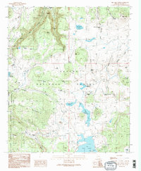
1991 Map of Big Lake North
USGS Topo · Published 1991About this map
Apache National Forest dominates this high-altitude landscape, where the headwaters of the Little Colorado River begin their descent. The map documents a transition between protected lands, bordering the Mount Baldy Wilderness to the west and the Fort Apache Indian Reservation to the south. Human presence is marked by seasonal cabins and utilitarian outposts, such as Phelps Cabin, Voigt Cabin, and the Thompson Ranch. These settlements are linked by a network of pack trails and old wagon ways, indicating a history of ranching and early forest management.
Find a feature on this map
64 named features on this map. Tap any name to fly to it.
Don’t see what you’re looking for? This feature index may not catch every label — zoom into the map to look around manually.
Map Details
Editions of this 1991 Big Lake North Map
2 editions found
Other maps of this area

1886 · St Johns
USGS Topo · 1:250,000

1892 · St Johns
USGS Topo · 1:250,000

1922 · Nutrioso
USGS Topo · 1:125,000

1954 · Clifton
USGS Topo · 1:250,000

1954 · Saint Johns
USGS Topo · 1:250,000

1957 · Clifton
USGS Topo · 1:250,000

1957 · Saint Johns
USGS Topo · 1:250,000

1958 · Clifton
USGS Topo · 1:250,000

1958 · Saint Johns
USGS Topo · 1:250,000

1958 · Big Lake
USGS Topo · 1:62,500