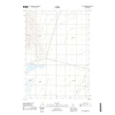
2020 Map of Big Lost River Sinks
USGS Topo · Published 2020About this map
The Lemhi Range terminates into the desert floor here, where the hydrology of Butte County takes a peculiar turn. The map documents the Big Lost River Sinks, a terminal drainage point where surface water vanishes into the volcanic aquifer of the Snake River Plain. This arid landscape is defined by the Dry Channel Big Lost River, which cuts across the terrain as a reminder of the seasonal and historical water flow that once reached these flats more frequently. Human activity is sparse and primarily limited to utility and transport corridors like Lincoln Blvd and Cinder Butte Rd, which navigate the open land south of the mountains. The map provides a clear view of the public land survey system divisions, including t6n r30e and t5n r31e, illustrating the vast, unpopulated character of this high-desert region.
Find a feature on this map
9 named features on this map. Tap any name to fly to it.
Don’t see what you’re looking for? This feature index may not catch every label — zoom into the map to look around manually.
Map Details
Editions of this 2020 Big Lost River Sinks Map
This is the sole edition of this map. No revisions or reprints were ever made.
Other maps of this area

1955 · Idaho Falls
USGS Topo · 1:250,000

1958 · Idaho Falls
USGS Topo · 1:250,000

1969 · Little Lost River Sinks
USGS Topo · 1:24,000

1969 · Circular Butte
USGS Topo · 1:24,000

1969 · Circular Butte NW
USGS Topo · 1:24,000

1969 · Richard Butte
USGS Topo · 1:24,000

1969 · Tyler Peak
USGS Topo · 1:24,000

1969 · Big Lost River Sinks
USGS Topo · 1:24,000

1973 · Little Butte NW
USGS Topo · 1:24,000

1973 · Circular Butte 3 NE
USGS Topo · 1:24,000