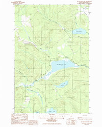
1985 Map of Big Machias Lake
USGS Topo · Published 1986About this map
Big Machias Lake and its surrounding watershed define this portion of the North Maine Woods during the mid-1980s. This unorganized territory, divided into townships such as T 12 R 8 Wels and T 11 R 9 Wels, is characterized by a dense network of water bodies and timber-access infrastructure. The Machias River flows through the central terrain, fed by tributaries like Dead Brook and Twentyfive Mile Brook. Significant water features including McGowan Lake, Rowe Lake, and Pratt Lake dot the landscape, many with recorded water elevations. The presence of several Campsites and a network of private roads suggests the area's primary use for commercial forestry and seasonal recreation. High points like Bishop Mountain provide relief in a region otherwise dominated by the complex drainage patterns of Twentymile Brook and Clayton Stream.
Find a feature on this map
26 named features on this map. Tap any name to fly to it.
Don’t see what you’re looking for? This feature index may not catch every label — zoom into the map to look around manually.
Map Details
Editions of this 1985 Big Machias Lake Map
This is the sole edition of this map. No revisions or reprints were ever made.
Other maps of this area

1928 · Winterville
USGS Topo · 1:48,000

1930 · Greenlaw
USGS Topo · 1:48,000

1931 · Fish River Lake
USGS Topo · 1:48,000

1931 · Mooseleuk Lake
USGS Topo · 1:48,000

1931 · Winterville
USGS Topo · 1:62,500

1933 · Greenlaw
USGS Topo · 1:62,500

1935 · Fish River Lake
USGS Topo · 1:62,500

1935 · Mooseleuk Lake
USGS Topo · 1:62,500

1954 · Presque Isle
USGS Topo · 1:250,000

1958 · Presque Isle
USGS Topo · 1:250,000