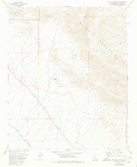
1971 Map of Big Maria Mts SW
USGS Topo · Published 1980About this map
The Big Maria Mountains dominate this arid Riverside County landscape, characterized by steep desert slopes and a network of mining exploration sites. In the early 1970s, the terrain was primarily used for mineral extraction and transit, evidenced by numerous prospects, scattered Mines, and a Gravel Pit located along the flats. The southeastern portion of the map shows the transition from the rugged highlands down toward the Colorado River valley, though the map remains focused on the high-elevation peaks and the Black Hill landmark.
Find a feature on this map
13 named features on this map. Tap any name to fly to it.
Don’t see what you’re looking for? This feature index may not catch every label — zoom into the map to look around manually.
Map Details
Editions of this 1971 Big Maria Mts SW Map
2 editions found
Other maps of this area

1942 · Blythe
USGS Topo · 1:250,000

1945 · Big Maria Mtns
USGS Topo · 1:62,500

1945 · Midland
USGS Topo · 1:62,500

1951 · Big Maria Mts
USGS Topo · 1:62,500

1951 · McCoy Wash
USGS Topo · 1:24,000

1951 · Blythe NE
USGS Topo · 1:24,000

1952 · Midland
USGS Topo · 1:62,500

1952 · Mc Coy Spring
USGS Topo · 1:62,500

1954 · Salton Sea
USGS Topo · 1:250,000
1954 · Big Maria Mts. NE
USGS Topo · 1:24,000