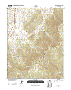
2013 Map of Big Meadows
USGS Topo · Published 2013About this map
Shenandoah National Park dominates this portion of the Blue Ridge, where the high-altitude plateau of Big Meadows serves as a central landmark for the surrounding wilderness. The terrain is defined by dramatic changes in elevation, featuring numerous waterfalls such as Dark Hollow Falls, Lewis Spring Falls, and Rose River Falls. Along the western slopes and valley floors, long-established settlements like Marksville, Blaineville, and Cavetown anchor the local road network. The map detail reflects the transition from agricultural valley life to the protected lands of the park, capturing family-named landmarks like Hershberger Hill and Varner Hill. Notable hiking and recreation sites, including the Byrds Nest Number 2 Shelter and the overlooks at Franklin Cliffs, are shown alongside the winding course of the Skyline Drive. This survey documents the intersection of rural Virginia community history with the established boundaries of one of the East Coast’s most prominent protected landscapes.
Find a feature on this map
163 named features on this map. Tap any name to fly to it.
Don’t see what you’re looking for? This feature index may not catch every label — zoom into the map to look around manually.
Map Details
Editions of this 2013 Big Meadows Map
This is the sole edition of this map. No revisions or reprints were ever made.
Other maps of this area

1892 · Woodstock
USGS Topo · 1:125,000

1892 · Gordonsville
USGS Topo · 1:125,000

1892 · Harrisonburg
USGS Topo · 1:125,000

1893 · Luray
USGS Topo · 1:125,000

1905 · Luray
USGS Topo · 1:125,000

1929 · Stony Man
USGS Topo · 1:48,000

1930 · Madison
USGS Topo · 1:48,000

1933 · Stony Man
USGS Topo · 1:62,500

1933 · Madison
USGS Topo · 1:62,500

1937 · Elkton
USGS Topo · 1:62,500