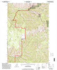
1995 Map of Big Meadows
USGS Topo · Published 1998About this map
The Umatilla National Forest contains a complex network of ridgelines and water sources, prominently featuring the Mill Creek Watershed and its strictly defined Intake Watershed Boundary. This high-elevation terrain is defined by dramatic elevation changes between Broken Ridge and the deep incisions of Henry Canyon. The landscape serves as a critical headwater region where the North Fork Walla Walla River and South Fork Walla Walla River begin their descent.
Find a feature on this map
28 named features on this map. Tap any name to fly to it.
Don’t see what you’re looking for? This feature index may not catch every label — zoom into the map to look around manually.
Map Details
Editions of this 1995 Big Meadows Map
This is the sole edition of this map. No revisions or reprints were ever made.
Other maps of this area

1919 · Walla Walla
USGS Topo · 1:125,000

1921 · Walla Walla
USGS Topo · 1:125,000

1937 · Pomeroy
USGS Topo · 1:96,000

1942 · Pomeroy
USGS Topo · 1:125,000

1953 · Pendleton
USGS Topo · 1:250,000

1953 · Walla Walla
USGS Topo · 1:250,000

1955 · Pullman
USGS Topo · 1:250,000

1955 · Grangeville
USGS Topo · 1:250,000

1956 · Pendleton
USGS Topo · 1:250,000

1958 · Pullman
USGS Topo · 1:250,000