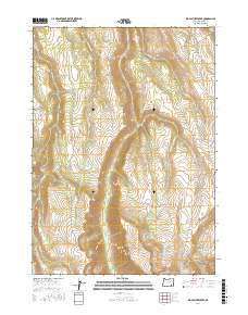
2017 Map of Big Pasture Creek
USGS Topo · Published 2017About this map
Steens Mtn dominates this high-elevation landscape in Harney County, where deep canyons and high ridges dictate the movement of water and travel. The dramatic Kiger Gorge serves as a central landmark, receiving drainage from Kiger Cr as it cuts through the complex topography. To the south, a curious landform known as Hole in the Ground sits near the headwaters of House Cr, illustrating the unique geological character of this part of the Oregon high country.
Find a feature on this map
23 named features on this map. Tap any name to fly to it.
Don’t see what you’re looking for? This feature index may not catch every label — zoom into the map to look around manually.
Map Details
Editions of this 2017 Big Pasture Creek Map
This is the sole edition of this map. No revisions or reprints were ever made.
Other maps of this area

1955 · Adel
USGS Topo · 1:250,000

1957 · Adel
USGS Topo · 1:250,000

1958 · Adel
USGS Topo · 1:250,000

1962 · Adel
USGS Topo · 1:250,000

1968 · Poison Springs
USGS Topo · 1:24,000

1968 · Fish Lake
USGS Topo · 1:24,000

1968 · Wildhorse Lake
USGS Topo · 1:24,000
1968 · Krumbo Ridge
USGS Topo · 1:24,000

1968 · Big Pasture Creek
USGS Topo · 1:24,000
1968 · Mc Coy Ridge
USGS Topo · 1:24,000