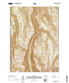
2020 Map of Big Pasture Creek
USGS Topo · Published 2020About this map
Steens Mtn dominates the eastern landscape of this high-elevation Harney County terrain, characterized by dramatic glacial carvings such as Kiger Gorge. The drainage patterns here are complex, with waters flowing through systems like Kiger Cr, McCoy Cr, and Cucamonga Cr. While much of the area is defined by its natural topography, including McCoy Ridge and the distinct depression known as Hole in the Ground, the human presence is marked by sparse infrastructure like Mann Creek Ln. This 2020 layout illustrates how modern land management boundaries, designated by townships such as t31s r33e and t32s r34e, overlay a rugged basin-and-range environment where seasonal waterways like Basque Cr and Big Pasture Cr shape the land's utility and character.
Find a feature on this map
22 named features on this map. Tap any name to fly to it.
Don’t see what you’re looking for? This feature index may not catch every label — zoom into the map to look around manually.
Map Details
Editions of this 2020 Big Pasture Creek Map
This is the sole edition of this map. No revisions or reprints were ever made.
Other maps of this area

1955 · Adel
USGS Topo · 1:250,000

1957 · Adel
USGS Topo · 1:250,000

1958 · Adel
USGS Topo · 1:250,000

1962 · Adel
USGS Topo · 1:250,000

1968 · Poison Springs
USGS Topo · 1:24,000

1968 · Fish Lake
USGS Topo · 1:24,000

1968 · Wildhorse Lake
USGS Topo · 1:24,000
1968 · Krumbo Ridge
USGS Topo · 1:24,000

1968 · Big Pasture Creek
USGS Topo · 1:24,000
1968 · Mc Coy Ridge
USGS Topo · 1:24,000