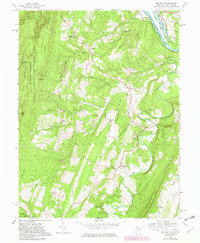
1958 Map of Big Pool
USGS Topo · Published 1982About this map
The Potomac River carves a dramatic S-curve at the boundary of Maryland and West Virginia, serving as the central artery for transportation and conservation. Along its northern bank, the Chesapeake and Ohio Canal and the Western Maryland Railway run parallel, illustrating the competition between rail and water transport that defined this corridor. The landscape is dominated by the ridges of Sleepy Creek Mountain and North Mountain, with the Sleepy Creek Public Hunting and Fishing Area preserving a significant portion of the highland interior.
Find a feature on this map
46 named features on this map. Tap any name to fly to it.
Don’t see what you’re looking for? This feature index may not catch every label — zoom into the map to look around manually.
Map Details
Editions of this 1958 Big Pool Map
4 editions found
Other maps of this area

1884 · Harpers Ferry
USGS Topo · 1:125,000

1891 · Harpers Ferry
USGS Topo · 1:125,000

1893 · Harpers Ferry
USGS Topo · 1:125,000

1894 · Winchester
USGS Topo · 1:125,000

1899 · Hancock
USGS Topo · 1:62,500

1901 · Hancock
USGS Topo · 1:62,500

1912 · Williamsport
USGS Topo · 1:62,500

1914 · Martinsburg
USGS Topo · 1:48,000

1914 · Gerrardstown
USGS Topo · 1:48,000

1916 · Gerrardstown
USGS Topo · 1:62,500