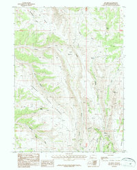
1987 Map of Big Ridge
USGS Topo · Published 1987About this map
Big Ridge dominates the center of this Wyoming quadrangle, serving as a high divide between several complex drainage systems in Sweetwater County. The landscape is defined by its water sources and sharp elevations, from the heights of Ramsey Peak and Sugarloaf to the distinct geological constriction known as The Narrows. Many labels reflect the essential role of water in this arid high-country environment, noting locations such as Coyote Spring, Spitzi Spring, and Dipping Spring.
Find a feature on this map
27 named features on this map. Tap any name to fly to it.
Don’t see what you’re looking for? This feature index may not catch every label — zoom into the map to look around manually.
Map Details
Editions of this 1987 Big Ridge Map
This is the sole edition of this map. No revisions or reprints were ever made.
Other maps of this area

1954 · Rock Springs
USGS Topo · 1:250,000

1957 · Currant Creek Ranch
USGS Topo · 1:62,500

1957 · Firehole Basin
USGS Topo · 1:62,500

1958 · Rock Springs
USGS Topo · 1:250,000

1962 · Rock Springs
USGS Topo · 1:250,000
1963 · Maxon Ranch
USGS Topo · 1:24,000
1963 · Richards Gap
USGS Topo · 1:24,000

1966 · Firehole Basin
USGS Topo · 1:62,500

1966 · Currant Creek Ranch
USGS Topo · 1:62,500
1968 · Earnest Butte
USGS Topo · 1:24,000