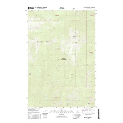
2017 Map of Big Rock Mountain
USGS Topo · Published 2017About this map
Stuart Hot Springs and the headwaters of the Three Links Cr drainage define this section of the Nez Perce National Forest. The landscape is a complex network of high summits and deep creek beds, anchored by the massive Big Rock Mountain and the prominent North Peak. Several important ridgelines, including Blacktail Ridge and Sixtytwo Ridge, provide natural corridors between the many drainages. The abundance of water sources, from Parsons Spring to High Spring, suggests the area's importance for local wildlife and seasonal movement through the interior of Idaho County. This 2017 survey details the precise topography of remote landmarks like Three Links Point and Meeker Point, offering a contemporary record of a wilderness largely defined by its natural hydrology and sharp vertical relief.
Find a feature on this map
33 named features on this map. Tap any name to fly to it.
Don’t see what you’re looking for? This feature index may not catch every label — zoom into the map to look around manually.
Map Details
Editions of this 2017 Big Rock Mountain Map
This is the sole edition of this map. No revisions or reprints were ever made.
Other maps of this area

1911 · Lolo
USGS Topo · 1:250,000

1913 · Lolo
USGS Topo · 1:250,000

1956 · Hamilton
USGS Topo · 1:250,000

1959 · Hamilton
USGS Topo · 1:250,000

1960 · Hamilton
USGS Topo · 1:250,000

1964 · Hamilton
USGS Topo · 1:250,000

1966 · Mc Connell Mtn
USGS Topo · 1:24,000

1966 · Moose Ridge
USGS Topo · 1:24,000
1966 · Fog Mountain
USGS Topo · 1:24,000
1966 · Big Rock Mtn
USGS Topo · 1:24,000