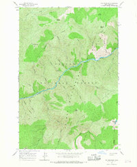
1966 Map of Fog Mountain
USGS Topo · Published 1968About this map
Nezperce National Forest dominates this mid-1960s survey of the Idaho backcountry, where the Selway River cuts a deep path through the terrain. The map captures a wild landscape defined by high peaks and an extensive network of foot travel, as shown by the numerous Pack Trails that provided the only overland access through the Selway-Bitterroot Wilderness Boundary. A primary vantage point for fire management and navigation is found at the Indian Hill Lookout Tower in the southwest corner. Significant topographical features like Fog Mountain, Big Fog Saddle, and Otter Butte overlook a series of drainages, including Ballinger Creek and Canteen Creek. The absence of established land lines or roads highlights the primitive nature of this region during the mid-century period, where landmarks like Moose Meadows and the Highline Lakes served as critical waypoints for those traversing the high ridges.
Find a feature on this map
29 named features on this map. Tap any name to fly to it.
Don’t see what you’re looking for? This feature index may not catch every label — zoom into the map to look around manually.
Map Details
Editions of this 1966 Fog Mountain Map
3 editions found
Other maps of this area

1911 · Lolo
USGS Topo · 1:250,000

1913 · Lolo
USGS Topo · 1:250,000

1956 · Elk City
USGS Topo · 1:250,000

1956 · Hamilton
USGS Topo · 1:250,000

1959 · Hamilton
USGS Topo · 1:250,000

1960 · Elk City
USGS Topo · 1:250,000

1960 · Hamilton
USGS Topo · 1:250,000

1964 · Hamilton
USGS Topo · 1:250,000

1966 · Selway Falls
USGS Topo · 1:24,000

1966 · Anderson Butte
USGS Topo · 1:24,000