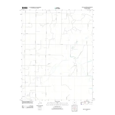
2012 Map of Big Salt Marsh
USGS Topo · Published 2012About this map
Big Salt Marsh and the surrounding hydraulic landscape of Stafford County define this central Kansas region. The map highlights a complex water management system where natural features like Boiling Springs and Salt Cr meet engineered waterways including the Rattlesnake Canal and West Canal. This intersection of geography and utility illustrates the ongoing effort to manage the high salinity and water levels of the marsh basin.
Find a feature on this map
21 named features on this map. Tap any name to fly to it.
Don’t see what you’re looking for? This feature index may not catch every label — zoom into the map to look around manually.
Map Details
Editions of this 2012 Big Salt Marsh Map
This is the sole edition of this map. No revisions or reprints were ever made.
Other maps of this area

1891 · Great Bend
USGS Topo · 1:125,000

1893 · Great Bend
USGS Topo · 1:125,000

1894 · Lyons
USGS Topo · 1:125,000

1955 · Great Bend
USGS Topo · 1:250,000

1957 · Great Bend
USGS Topo · 1:250,000

1957 · Ellinwood SW
USGS Topo · 1:24,000

1957 · Ellinwood
USGS Topo · 1:24,000

1958 · Great Bend
USGS Topo · 1:250,000

1967 · Alden NW
USGS Topo · 1:24,000
1970 · Raymond
USGS Topo · 1:24,000