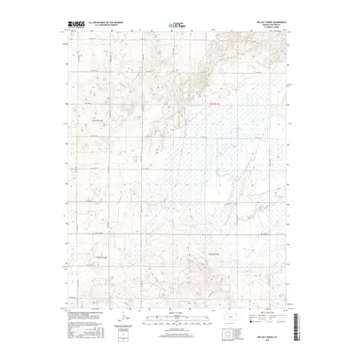
2015 Map of Big Salt Marsh
USGS Topo · Published 2015About this map
Big Salt Marsh dominates this portion of Stafford County, defining a landscape where saline wetlands and intricate water management systems meet the rigid grid of the Public Land Survey System. The area is characterized by a complex hydrographic network, including the flowing Boiling Springs and the managed waters of the Rattlesnake Canal and West Canal. These canals represent significant 20th-century hydrological engineering designed to control drainage in this unique inland salt marsh environment. The section lines are clearly marked by a persistent network of county roads, such as NE 170th St and NE 90th Ave, which carve the prairie into precise townships like t21s r11w. This map captures the intersection of natural saline ecology and agricultural land division in the Kansas plains.
Find a feature on this map
25 named features on this map. Tap any name to fly to it.
Don’t see what you’re looking for? This feature index may not catch every label — zoom into the map to look around manually.
Map Details
Editions of this 2015 Big Salt Marsh Map
This is the sole edition of this map. No revisions or reprints were ever made.
Other maps of this area

1891 · Great Bend
USGS Topo · 1:125,000

1893 · Great Bend
USGS Topo · 1:125,000

1894 · Lyons
USGS Topo · 1:125,000

1955 · Great Bend
USGS Topo · 1:250,000

1957 · Great Bend
USGS Topo · 1:250,000

1957 · Ellinwood SW
USGS Topo · 1:24,000

1957 · Ellinwood
USGS Topo · 1:24,000

1958 · Great Bend
USGS Topo · 1:250,000

1967 · Alden NW
USGS Topo · 1:24,000
1970 · Raymond
USGS Topo · 1:24,000