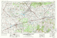
1954 Map of Big Spring
USGS Topo · Published 1984About this map
Big Spring serves as the focal point of this mid-century West Texas landscape, a region defined by its transition from high plains to the brakes of the Colorado River. The infrastructure of the Cold War era is prominently visible at Webb Air Force Base and its associated Webb Training Annex, reflecting the strategic military presence in the Permian Basin during the 1950s. The regional economy is anchored by the Texas and Pacific railroad, which strings together communities like Coahoma, Stanton, and Snyder.
Find a feature on this map
130 named features on this map. Tap any name to fly to it.
Don’t see what you’re looking for? This feature index may not catch every label — zoom into the map to look around manually.
Map Details
Editions of this 1954 Big Spring Map
4 editions found

Other maps of this area

1890 · Abilene
USGS Topo · 1:125,000

1891 · Hayrick
USGS Topo · 1:125,000

1891 · Anson
USGS Topo · 1:125,000

1892 · Abilene
USGS Topo · 1:125,000

1892 · Ballinger
USGS Topo · 1:125,000

1893 · Roby
USGS Topo · 1:125,000

1893 · Anson
USGS Topo · 1:125,000

1893 · Sweetwater
USGS Topo · 1:125,000

1894 · Hayrick
USGS Topo · 1:125,000

1921 · Bronte
USGS Topo · 1:31,680