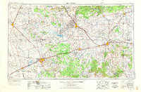
1954 Map of Big Spring
USGS Topo · Published 1976About this map
Big Spring and the surrounding West Texas plains are defined by a landscape of scattered ranching hubs and growing oil infrastructure during the mid-1950s. The regional economy is anchored by the Texas and Pacific railroad, which strings together settlements like Coahoma, Stanton, and Snyder across the arid terrain. Military activity is prominent at Webb Air Force Base, while the nearby Webb Training Annex and Big Spring State Park highlight the diverse land use in Howard County.
Find a feature on this map
146 named features on this map. Tap any name to fly to it.
Don’t see what you’re looking for? This feature index may not catch every label — zoom into the map to look around manually.
Map Details
Editions of this 1954 Big Spring Map
4 editions found

Other maps of this area

1890 · Abilene
USGS Topo · 1:125,000

1891 · Hayrick
USGS Topo · 1:125,000

1891 · Anson
USGS Topo · 1:125,000

1892 · Abilene
USGS Topo · 1:125,000

1892 · Ballinger
USGS Topo · 1:125,000

1893 · Roby
USGS Topo · 1:125,000

1893 · Anson
USGS Topo · 1:125,000

1893 · Sweetwater
USGS Topo · 1:125,000

1894 · Hayrick
USGS Topo · 1:125,000

1921 · Bronte
USGS Topo · 1:31,680