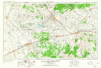
1954 Map of Big Spring
USGS Topo · Published 1967About this map
The upper reaches of the Colorado River and the Clear Fork Brazos River dominate this West Texas landscape during a period of mid-century infrastructure growth. The 1966 revision highlights the emergence of significant water projects such as Lake J B Thomas, Lake Colorado City, and the Champion Creek Reservoir, which altered the arid terrain of the Permian Basin. This survey captures the strategic importance of Webb Air Force Base at Big Spring, a major regional hub where the Texas and Pacific railroad follows the path of US Highway 80. To the east, Sweetwater serves as a critical rail junction for the Panhandle and Santa Fe and Missouri-Kansas-Texas lines. Distinctive landmarks like Muchakooago Peak and the Signal Mountains rise above the surrounding draws, including Mustang Draw and Sulphur Springs Draw, providing natural orientation in a region increasingly defined by oil fields and ranching.
Find a feature on this map
95 named features on this map. Tap any name to fly to it.
Don’t see what you’re looking for? This feature index may not catch every label — zoom into the map to look around manually.
Map Details
Editions of this 1954 Big Spring Map
4 editions found

Other maps of this area

1890 · Abilene
USGS Topo · 1:125,000

1891 · Hayrick
USGS Topo · 1:125,000

1891 · Anson
USGS Topo · 1:125,000

1892 · Abilene
USGS Topo · 1:125,000

1892 · Ballinger
USGS Topo · 1:125,000

1893 · Roby
USGS Topo · 1:125,000

1893 · Anson
USGS Topo · 1:125,000

1893 · Sweetwater
USGS Topo · 1:125,000

1894 · Hayrick
USGS Topo · 1:125,000

1921 · Bronte
USGS Topo · 1:31,680