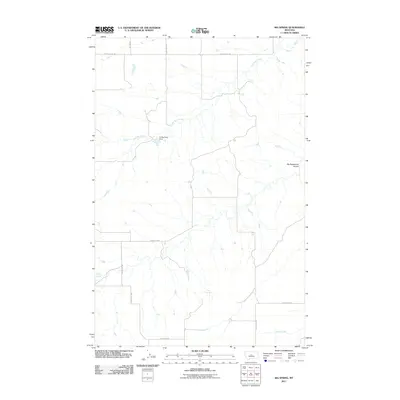
2011 Map of Big Spring
USGS Topo · Published 2011About this map
Dry Wolf Creek winds through this Fergus County landscape, tracing a path through the open ranching country of central Montana. The presence of the Coffee Cake Dam and the eponymous Big Spring highlight the critical importance of water management in this semi-arid region. The map reveals a structured grid of rural infrastructure, where local transport is defined by routes such as Iowa Bench Rd and Pacer Coulee Rd. These roads connect isolated holdings across the undulating terrain, punctuated by features like the Big Sagebrush Coulee. To the south, Willow Creek and Indian Creek further define the drainage patterns of the area, providing a clear record of the geographic orientation and land divisions at the beginning of the second decade of the 2000s.
Find a feature on this map
14 named features on this map. Tap any name to fly to it.
Don’t see what you’re looking for? This feature index may not catch every label — zoom into the map to look around manually.
Map Details
Editions of this 2011 Big Spring Map
This is the sole edition of this map. No revisions or reprints were ever made.
Other maps of this area

1890 · Fort Benton
USGS Topo · 1:250,000

1892 · Fort Benton
USGS Topo · 1:250,000

1897 · Fort Benton
USGS Topo · 1:250,000

1954 · Great Falls
USGS Topo · 1:250,000

1954 · Lewistown
USGS Topo · 1:250,000

1957 · Great Falls
USGS Topo · 1:250,000

1959 · Lewistown
USGS Topo · 1:250,000

1970 · Harwood Bench
USGS Topo · 1:24,000
1970 · Moccasin
USGS Topo · 1:24,000
1970 · Kolin
USGS Topo · 1:24,000