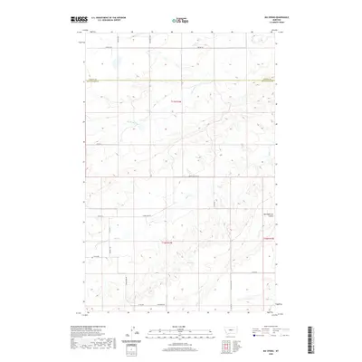
2020 Map of Big Spring
USGS Topo · Published 2020About this map
Big Spring serves as the focal point of this Central Montana landscape, where the plateaus of Fergus and Judith Basin Counties meet. The map reveals a transition between elevated benchlands and the deep incisions of coulees and creek beds. To the north, the terrain is defined by the agricultural reach of Iowa Bench Rd and Hoosac Rd, while the southern portion of the quadrangle drops into the drainage basins of Sage Cr and Indian Cr. The appearance of Big Sagebrush Coulee in the east highlights the persistent brush-land character of the regional topography. This survey shows the modern rural road network, including family and geographic markers like Melton Rd and Indian Butte Rd, tracing the persistent patterns of ranching and land use in this sparsely settled region of the Great Plains.
Find a feature on this map
24 named features on this map. Tap any name to fly to it.
Don’t see what you’re looking for? This feature index may not catch every label — zoom into the map to look around manually.
Map Details
Editions of this 2020 Big Spring Map
This is the sole edition of this map. No revisions or reprints were ever made.
Other maps of this area

1890 · Fort Benton
USGS Topo · 1:250,000

1892 · Fort Benton
USGS Topo · 1:250,000

1897 · Fort Benton
USGS Topo · 1:250,000

1954 · Great Falls
USGS Topo · 1:250,000

1954 · Lewistown
USGS Topo · 1:250,000

1957 · Great Falls
USGS Topo · 1:250,000

1959 · Lewistown
USGS Topo · 1:250,000

1970 · Harwood Bench
USGS Topo · 1:24,000
1970 · Moccasin
USGS Topo · 1:24,000
1970 · Kolin
USGS Topo · 1:24,000