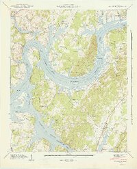
1943 Map of Big Spring
USGS Topo · Published 1946About this map
The Tennessee River and Hiwassee River converge in this mid-century survey, creating a landscape dominated by the backwaters of the Chickamauga Reservoir. The topography reflects a region in transition during the early 1940s, where river-based transport like the Cotton Port Ferry still operated alongside new infrastructure such as the Malaria Control Base and a Landing Field.
Find a feature on this map
66 named features on this map. Tap any name to fly to it.
Don’t see what you’re looking for? This feature index may not catch every label — zoom into the map to look around manually.
Map Details
Editions of this 1943 Big Spring Map
2 editions found
Other maps of this area

1886 · Cleveland
USGS Topo · 1:125,000

1887 · Kingston
USGS Topo · 1:125,000

1888 · Chattanooga
USGS Topo · 1:125,000

1891 · Kingston
USGS Topo · 1:125,000

1892 · Pikeville
USGS Topo · 1:125,000

1892 · Cleveland
USGS Topo · 1:125,000

1893 · Chattanooga
USGS Topo · 1:125,000

1893 · Kingston
USGS Topo · 1:125,000

1895 · Cleveland
USGS Topo · 1:125,000

1895 · Pikeville
USGS Topo · 1:125,000