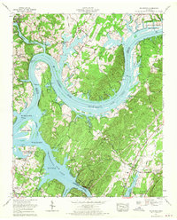
1967 Map of Big Spring
USGS Topo · Published 1970About this map
The Tennessee River and the expansive Chickamauga Lake dominate this mid-century landscape, illustrating the profound impact of the Tennessee Valley Authority on the region. Significant bends in the river, such as Armstrong Bend and Gillespie Bend, frame a terrain rich with local history, including an Indian mound near the riverbank. This era of the late 1960s shows a transitional period where agricultural infrastructure like Cotton Port Road meets modern developments such as Mark Anton Airfield and William Jennings Bryan University.
Find a feature on this map
63 named features on this map. Tap any name to fly to it.
Don’t see what you’re looking for? This feature index may not catch every label — zoom into the map to look around manually.
Map Details
Editions of this 1967 Big Spring Map
3 editions found
Other maps of this area

1886 · Cleveland
USGS Topo · 1:125,000

1887 · Kingston
USGS Topo · 1:125,000

1888 · Chattanooga
USGS Topo · 1:125,000

1891 · Kingston
USGS Topo · 1:125,000

1892 · Pikeville
USGS Topo · 1:125,000

1892 · Cleveland
USGS Topo · 1:125,000

1893 · Chattanooga
USGS Topo · 1:125,000

1893 · Kingston
USGS Topo · 1:125,000

1895 · Cleveland
USGS Topo · 1:125,000

1895 · Pikeville
USGS Topo · 1:125,000