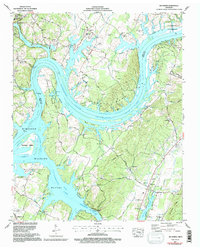
1967 Map of Big Spring
USGS Topo · Published 1996About this map
The Tennessee River snakes through the heart of this landscape, its deep curves forming prominent landforms like Armstrong Bend and Gillespie Bend. The inundation of Chickamauga Lake has created a complex shoreline of sloughs and backwaters, including Ziegler Slough and Good Hope Slough, which dominate the central terrain. This aquatic environment is defined by extensive conservation areas such as the Hiwassee Wildlife Refuge and Cotton Port Wildlife Management Area, which protect the river islands and wetlands.
Find a feature on this map
74 named features on this map. Tap any name to fly to it.
Don’t see what you’re looking for? This feature index may not catch every label — zoom into the map to look around manually.
Map Details
Editions of this 1967 Big Spring Map
3 editions found
Other maps of this area

1886 · Cleveland
USGS Topo · 1:125,000

1887 · Kingston
USGS Topo · 1:125,000

1888 · Chattanooga
USGS Topo · 1:125,000

1891 · Kingston
USGS Topo · 1:125,000

1892 · Pikeville
USGS Topo · 1:125,000

1892 · Cleveland
USGS Topo · 1:125,000

1893 · Chattanooga
USGS Topo · 1:125,000

1893 · Kingston
USGS Topo · 1:125,000

1895 · Cleveland
USGS Topo · 1:125,000

1895 · Pikeville
USGS Topo · 1:125,000