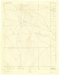
1893 Map of Big Springs
USGS Topo · Published 1900About this map
The high plains of eastern El Paso County at the end of the nineteenth century were defined by isolated water sources and early livestock ranching. This reconnaissance survey, conducted in 1889, captures the landscape of the Colorado frontier before intensive irrigation or major development. At the center of the sheet lies Big Springs, a critical node in the local drainage network where trails converged near Black Squirrel Creek. To the north, the Holcolm Hills break the horizon, while the eastern edge follows the boundaries of Elbert and Lincoln counties. The map provides specific genealogical value for families associated with early landholdings such as Galloway Ranch, Hancock Ranch, and the lonely outpost at Crows Roost. The sparse distribution of named points like Holtwold underscores the vast distances between established settlements during this era.
Find a feature on this map
14 named features on this map. Tap any name to fly to it.
Don’t see what you’re looking for? This feature index may not catch every label — zoom into the map to look around manually.
Map Details
Editions of this 1893 Big Springs Map
5 editions found
Other maps of this area

1889 · Sanborn
USGS Topo · 1:125,000

1891 · Sanborn
USGS Topo · 1:125,000

1891 · Catlin
USGS Topo · 1:125,000

1891 · Pueblo
USGS Topo · 1:125,000

1891 · Nepesta
USGS Topo · 1:125,000

1891 · Limon
USGS Topo · 1:125,000

1892 · Limon
USGS Topo · 1:125,000

1893 · Nepesta
USGS Topo · 1:125,000

1893 · Sanborn
USGS Topo · 1:125,000

1893 · Big Springs
USGS Topo · 1:125,000