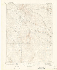
1893 Map of Big Springs
USGS Topo · Published 1948About this map
Big Springs stands as the central landmark of this high plains landscape at the end of the 19th century. Surveyed by A.H. Thompson and Willard D. Johnson, the map reveals a sparsely populated territory where early ranching outposts like Galloway Ranch and Hancock Ranch provided the primary human footprint. The topography is defined by the drainage patterns of Black Squirrel Creek and Horse Creek, which cut through the terrain below the Holcolm Hills. This early reconnaissance survey captures the region before extensive modern development, documenting the isolated settlements of Holtwold and Crows Roost that once served as vital stopovers for travelers and stockmen moving through the intersection of El Paso and Elbert counties.
Find a feature on this map
15 named features on this map. Tap any name to fly to it.
Don’t see what you’re looking for? This feature index may not catch every label — zoom into the map to look around manually.
Map Details
Editions of this 1893 Big Springs Map
5 editions found
Other maps of this area

1889 · Sanborn
USGS Topo · 1:125,000

1891 · Sanborn
USGS Topo · 1:125,000

1891 · Catlin
USGS Topo · 1:125,000

1891 · Pueblo
USGS Topo · 1:125,000

1891 · Nepesta
USGS Topo · 1:125,000

1891 · Limon
USGS Topo · 1:125,000

1892 · Limon
USGS Topo · 1:125,000

1893 · Nepesta
USGS Topo · 1:125,000

1893 · Sanborn
USGS Topo · 1:125,000

1893 · Big Springs
USGS Topo · 1:125,000