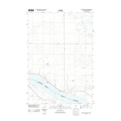
2013 Map of Big Stone Lake East
USGS Topo · Published 2013About this map
Big Stone Lake serves as the focal point for this landscape along the border of Minnesota and South Dakota, where the Minnesota River flows southeast through a well-defined valley. The region is characterized by a high density of rural burial grounds, including Elim Cem, Bailey Cem, W Saint Paul Cem, Lakeside Cem, and Mills Cem, suggesting a long-established network of small communities and church congregations. Transportation infrastructure centers on the transition from the plateau down to the water, with MN-7 and SD-109 tracing the river's path. Local aviation and navigation are represented by Shannon Field Airport and distinctive shoreline landmarks like Point Welcome and Lou Point. The grid of county highways and local avenues, such as Co HWY-7 and 480th Ave, illustrates the organized agricultural partition of the surrounding prairie lands.
Find a feature on this map
22 named features on this map. Tap any name to fly to it.
Don’t see what you’re looking for? This feature index may not catch every label — zoom into the map to look around manually.
Map Details
Editions of this 2013 Big Stone Lake East Map
This is the sole edition of this map. No revisions or reprints were ever made.
Other maps of this area

1916 · Beardsley
USGS Topo · 1:62,500

1918 · Beardsley
USGS Topo · 1:62,500

1950 · Graceville
USGS Topo · 1:62,500

1953 · Ortonville
USGS Topo · 1:62,500

1953 · Milbank
USGS Topo · 1:250,000

1954 · Big Stone Lake
USGS Topo · 1:62,500

1958 · Milbank
USGS Topo · 1:250,000

1971 · Big Stone Lake East
USGS Topo · 1:24,000

1971 · Big Stone Lake West
USGS Topo · 1:24,000

1971 · Big Stone Lake SE
USGS Topo · 1:24,000