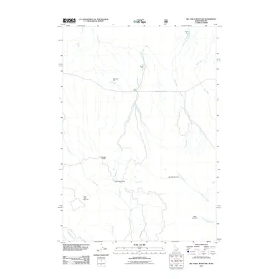
2011 Map of Big Table Mountain
USGS Topo · Published 2011About this map
Jones Ranch sits at the center of this high-elevation landscape straddling the Idaho-Montana border, where water management is defined by a series of small impoundments like Pands Dam, Cactus Dam, and Chandelier Dam. The terrain is dominated by the massive landforms of Big Table Mountain and Little Table Mountain, which rise above a complex network of drainages including Bean Creek, Bear Creek, and the many branches of Peet Creek. The map documents the critical watershed boundaries of the Price-Peet Divide and Pete Creek Divide, highlighting how the natural topography dictates the flow of water across this remote region. Transportation is limited to functional routes like the Southside Centennial Rd and Pete Creek RD, serving the sparse ranching and grazing lands found near Mule Meadows.
Find a feature on this map
23 named features on this map. Tap any name to fly to it.
Don’t see what you’re looking for? This feature index may not catch every label — zoom into the map to look around manually.
Map Details
Editions of this 2011 Big Table Mountain Map
This is the sole edition of this map. No revisions or reprints were ever made.
Other maps of this area

1950 · Lower Red Rock Lake
USGS Topo · 1:62,500

1955 · Dubois
USGS Topo · 1:250,000

1955 · Ashton
USGS Topo · 1:250,000

1958 · Dubois
USGS Topo · 1:250,000

1958 · Ashton
USGS Topo · 1:250,000

1960 · Ashton
USGS Topo · 1:250,000

1968 · Corral Creek
USGS Topo · 1:24,000

1968 · Big Table Mountain
USGS Topo · 1:24,000

1968 · Antelope Peak
USGS Topo · 1:24,000
1968 · Wolverine Creek
USGS Topo · 1:24,000