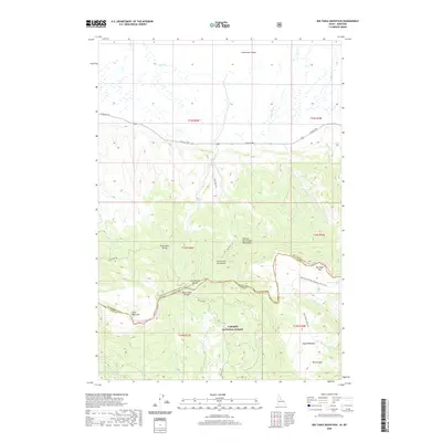
2020 Map of Big Table Mountain
USGS Topo · Published 2020About this map
The Continental Divide National Scenic Trail winds through this high-elevation landscape, marking the topographic spine where the Western Centennial Mountains meet the Targhee National Forest. This 2020 survey documents the complex watershed system of the Centennial Mountains, where numerous drainages like Peet Cr, Bean Cr, and Pete Creek flow north toward the Centennial Valley. Significant landforms including Big Table Mtn and Little Table Mtn anchor the southern portion of the sheet near the border of Montana and Idaho. The map illustrates a remote wilderness defined by intricate ridges and divides, most notably the Price-Peet Divide and Pete Creek Divide. Access to this high country is limited to rugged tracks such as S Valley Rd and Price Peet Rd, reflecting the primary use of the land for recreation, conservation, and resource management within the national forest system.
Find a feature on this map
36 named features on this map. Tap any name to fly to it.
Don’t see what you’re looking for? This feature index may not catch every label — zoom into the map to look around manually.
Map Details
Editions of this 2020 Big Table Mountain Map
This is the sole edition of this map. No revisions or reprints were ever made.
Other maps of this area

1950 · Lower Red Rock Lake
USGS Topo · 1:62,500

1955 · Dubois
USGS Topo · 1:250,000

1955 · Ashton
USGS Topo · 1:250,000

1958 · Dubois
USGS Topo · 1:250,000

1958 · Ashton
USGS Topo · 1:250,000

1960 · Ashton
USGS Topo · 1:250,000

1968 · Corral Creek
USGS Topo · 1:24,000

1968 · Big Table Mountain
USGS Topo · 1:24,000

1968 · Antelope Peak
USGS Topo · 1:24,000
1968 · Wolverine Creek
USGS Topo · 1:24,000