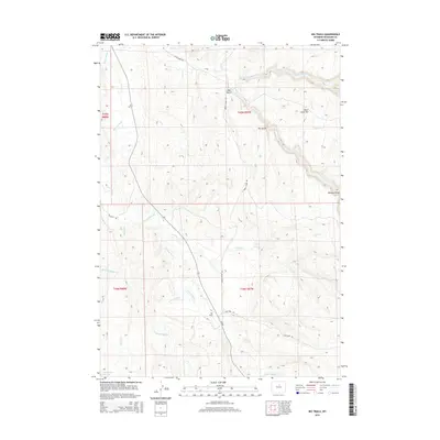
2015 Map of Big Trails
USGS Topo · Published 2015About this map
Nowood River cuts a prominent path through this high-plains landscape in southeastern Washakie County. The settlement of Big Trails serves as a central point in an area defined by complex drainage networks, including Crooked Cr and the multiple branches of Otter Cr. The terrain is marked by significant topographical features such as Red Gulch, Dry Gulch, and the distinctive Otter Creek Vee. The reliance on local water sources in this arid environment is evident from the presence of Big Spring and the Near Water Reservoir. A sparse road network, featuring Big Trails Rd and the aptly named Dry Farm Rd, connects the scattered ranching and agricultural operations that characterize the township boundaries of T44N and T45N.
Find a feature on this map
26 named features on this map. Tap any name to fly to it.
Don’t see what you’re looking for? This feature index may not catch every label — zoom into the map to look around manually.
Map Details
Editions of this 2015 Big Trails Map
This is the sole edition of this map. No revisions or reprints were ever made.
Other maps of this area

1955 · Arminto
USGS Topo · 1:250,000

1958 · Arminto
USGS Topo · 1:250,000

1962 · Arminto
USGS Topo · 1:250,000

1966 · Monument Hill
USGS Topo · 1:24,000

1966 · Big Trails
USGS Topo · 1:24,000

1966 · Big Trails NE
USGS Topo · 1:24,000
1966 · Tallon Spring
USGS Topo · 1:24,000

1966 · Indian Creek
USGS Topo · 1:24,000
1966 · Joe Emge Creek
USGS Topo · 1:24,000

1967 · Mahogany Butte
USGS Topo · 1:24,000