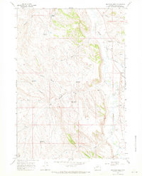
1966 Map of Joe Emge Creek
USGS Topo · Published 1971About this map
The Nowood River meanders through this portion of Washakie County, defining a landscape shaped by intermittent water management and high-desert drainage. Ranching infrastructure is prominent, evidenced by numerous named reservoirs such as Warner Reservoir, Flagstone Reservoir, and Bunning Reservoir. These water sources, along with features like Last Hope Reservoir and Right Angle Reservoir, suggest the critical importance of water rights and livestock grazing in the mid-1960s. Terrain features like Fiscus Gulch, Woods Gulch, and McClellan Gulch create a complex network of draws feeding into the larger river valley. Transportation at this time was limited to the unpaved Spring Creek Rd and various jeep trails, indicating a working landscape of ranching and exploration rather than residential development. A single Drill Hole and scattered gravel pits point to the localized extraction activities common in this part of Wyoming.
Find a feature on this map
27 named features on this map. Tap any name to fly to it.
Don’t see what you’re looking for? This feature index may not catch every label — zoom into the map to look around manually.
Map Details
Editions of this 1966 Joe Emge Creek Map
2 editions found
Other maps of this area

1899 · Cloud peak
USGS Topo · 1:125,000

1901 · Cloud Peak
USGS Topo · 1:125,000

1955 · Sheridan
USGS Topo · 1:250,000

1955 · Arminto
USGS Topo · 1:250,000

1958 · Sheridan
USGS Topo · 1:250,000

1958 · Arminto
USGS Topo · 1:250,000

1962 · Sheridan
USGS Topo · 1:250,000

1962 · Arminto
USGS Topo · 1:250,000

1966 · Big Trails
USGS Topo · 1:24,000

1966 · Big Trails NE
USGS Topo · 1:24,000