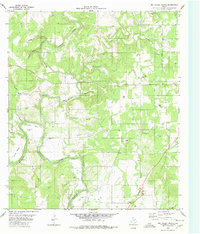
1980 Map of Big Valley North
USGS Topo · Published 1980About this map
The Colorado River and its confluence with Pecan Bayou define the rural geography along the boundary of Mills and San Saba Counties. This 1980 record illustrates a landscape of intermittent streams and family-named landmarks, where the vast Big Valley opens up to the south. The area is marked by several small rural burial grounds, including Rock Spring Cem, Traylor Cem, and Catclaw Cem, which serve as vital markers for local genealogical research. Local movement centers on corridors like Williams Ranch Road, connecting isolated ranch lands to community hubs like Big Valley Ch. The terrain is characterized by distinctive river features such as Horseshoe Bend and Smoky Bend, alongside numerous named drainages like Prescott Creek and Chambers Creek that feed into the larger river system.
Find a feature on this map
32 named features on this map. Tap any name to fly to it.
Don’t see what you’re looking for? This feature index may not catch every label — zoom into the map to look around manually.
Map Details
Editions of this 1980 Big Valley North Map
2 editions found
Other maps of this area

1885 · San Saba
USGS Topo · 1:125,000

1889 · Brownwood
USGS Topo · 1:125,000

1894 · Brownwood
USGS Topo · 1:125,000

1894 · San Saba
USGS Topo · 1:125,000

1925 · San Saba 2-a
USGS Topo · 1:48,000

1925 · Brownwood 3-d
USGS Topo · 1:48,000

1925 · San Saba 1-c
USGS Topo · 1:48,000

1925 · San Saba 1-b
USGS Topo · 1:48,000

1925 · San Saba 1-d
USGS Topo · 1:48,000

1925 · Brownwood 4-c
USGS Topo · 1:48,000