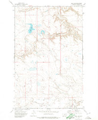
1971 Map of Bigby Lake
USGS Topo · Published 1974About this map
Fort Belknap Indian Reservation lands encompass this entire 1971 study, defined by a rolling prairie landscape north of the Little Rocky Mountains. The hydrology of the region is centered on the eponymous Bigby Lake, which sits as a prominent natural catch basin in the northwest quadrant. The terrain is deeply incised by seasonal drainage systems, most notably the meandering course of Fifteenmile Creek as it cuts through the central sections toward the east. This survey reveals a landscape largely devoid of permanent structural settlements, instead showing a network of unimproved roads and fine dashed lines indicating selected fence lines that speak to the vast open-range cattle ranching traditions of north-central Montana. In the southern portion, Peoples Creek and its South Fork Peoples Creek provide the primary water source for the arid landscape, while White Bear Creek drains the northern reaches.
Find a feature on this map
7 named features on this map. Tap any name to fly to it.
Don’t see what you’re looking for? This feature index may not catch every label — zoom into the map to look around manually.
Map Details
Editions of this 1971 Bigby Lake Map
This is the sole edition of this map. No revisions or reprints were ever made.
Other maps of this area

1953 · Havre
USGS Topo · 1:250,000

1957 · Havre
USGS Topo · 1:250,000

1958 · Havre
USGS Topo · 1:250,000

1964 · Threemile Reservoir
USGS Topo · 1:24,000

1964 · Coburg
USGS Topo · 1:24,000
1964 · Savoy
USGS Topo · 1:24,000

1964 · Weigand Reservoir
USGS Topo · 1:24,000

1971 · Lodge Pole NW
USGS Topo · 1:24,000

1971 · Lodge Pole NE
USGS Topo · 1:24,000
1971 · Wild Horse Butte
USGS Topo · 1:24,000