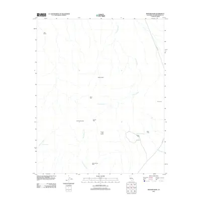
2012 Map of Bighorn Basin
USGS Topo · Published 2012About this map
The Granite Mountains dominate the southern portion of this high-desert landscape in San Bernardino County, where peaks like Silver Peak and Granite Peak overlook the expansive Bighorn Basin. Water is the primary sculptor of this terrain, evidenced by the intricate networks of the Cottonwood Wash and Van Winkle Wash that drain the central flats. Human activity is sparse but centered on reliable water sources and established routes, with Dorners Camp and Granite Cove positioned near the eastern edge. The presence of Budweiser Spring and Cove Spring highlights the critical importance of localized springs for survival in this arid environment. Transportation through this remote section of the Mojave is anchored by Kelbaker Rd, which provides a corridor through the basins and allows access to the Granite Peak Plateau and the uniquely named White Fang formation.
Find a feature on this map
18 named features on this map. Tap any name to fly to it.
Don’t see what you’re looking for? This feature index may not catch every label — zoom into the map to look around manually.
Map Details
Editions of this 2012 Bighorn Basin Map
This is the sole edition of this map. No revisions or reprints were ever made.
Other maps of this area

1942 · Amboy
USGS Topo · 1:250,000

1943 · Amboy
USGS Topo · 1:250,000

1954 · Needles
USGS Topo · 1:250,000

1956 · Needles
USGS Topo · 1:250,000

1956 · Cadiz
USGS Topo · 1:62,500
1956 · Bagdad
USGS Topo · 1:62,500

1956 · Flynn
USGS Topo · 1:62,500
1957 · Kerens
USGS Topo · 1:62,500
1960 · Bagdad
USGS Topo · 1:50,000

1981 · Needles
USGS Topo · 1:250,000