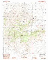
1984 Map of Bighorn Basin
USGS Topo · Published 1985About this map
The Granite Mountains dominate the southern half of this landscape, rising sharply above the expansive Bighorn Basin and the Willow Spring Basin. This 1980s survey captures a transition in land use within the East Mojave National Scenic Area, where traditional ranching and mining activities intersect with early desert preservation efforts. Small-scale resource extraction is evidenced by scattered prospects, while a network of named springs provides essential water in an arid environment, including Budweiser Spring, Coyote Springs, and Snake Spring.
Find a feature on this map
26 named features on this map. Tap any name to fly to it.
Don’t see what you’re looking for? This feature index may not catch every label — zoom into the map to look around manually.
Map Details
Editions of this 1984 Bighorn Basin Map
This is the sole edition of this map. No revisions or reprints were ever made.
Other maps of this area

1942 · Amboy
USGS Topo · 1:250,000

1943 · Amboy
USGS Topo · 1:250,000

1954 · Needles
USGS Topo · 1:250,000

1956 · Needles
USGS Topo · 1:250,000

1956 · Cadiz
USGS Topo · 1:62,500
1956 · Bagdad
USGS Topo · 1:62,500

1956 · Flynn
USGS Topo · 1:62,500
1957 · Kerens
USGS Topo · 1:62,500
1960 · Bagdad
USGS Topo · 1:50,000

1981 · Needles
USGS Topo · 1:250,000