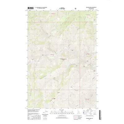
2017 Map of Bighorn Crags
USGS Topo · Published 2017About this map
Salmon River carving through the heart of the Salmon National Forest defines this high-elevation landscape in Lemhi County. The terrain is marked by sharp topographic relief, rising from the riverbanks to the eponymous Bighorn Crags and the summit of Sagebrush Mtn. This 2017 survey documents a network of remote access points including the Salmon River Rd and Panther Creek Rd, which provide passage to interior features like the Cove Creek Bridge. Geothermal activity is represented by the isolated Owl Creek Hot Springs located near East Owl Creek. The map also captures descriptive local toponyms such as Poverty Flat, Skull Gulch, and Corral Flat, reflecting the historical uses of this wilderness area for ranching and transit through the Idaho backcountry.
Find a feature on this map
41 named features on this map. Tap any name to fly to it.
Don’t see what you’re looking for? This feature index may not catch every label — zoom into the map to look around manually.
Map Details
Editions of this 2017 Bighorn Crags Map
This is the sole edition of this map. No revisions or reprints were ever made.
Other maps of this area

1950 · Blackbird Mtn
USGS Topo · 1:62,500

1951 · Blackbird Mtn
USGS Topo · 1:62,500

1956 · Elk City
USGS Topo · 1:250,000

1960 · Elk City
USGS Topo · 1:250,000

1960 · Shoup
USGS Topo · 1:62,500

1962 · Long Tom Mtn
USGS Topo · 1:24,000

1962 · Mt Mc Guire
USGS Topo · 1:24,000

1962 · Horse Creek Butte
USGS Topo · 1:24,000

1982 · Bighorn Crags
USGS Topo · 1:100,000
1989 · Gant Ridge
USGS Topo · 1:24,000