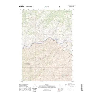
2023 Map of Bighorn Crags
USGS Topo · Published 2023About this map
The Salmon Wild and Scenic River carves a deep path through this remote portion of Lemhi County, defining a landscape dominated by protected federal lands. Much of the southern half of the map is occupied by the Frank Church-River of No Return Wilderness, a region where the topography rises sharply toward the Bighorn Crags and peaks like Sagebrush Mtn. Access to these high elevations is limited to footpaths such as the Bighorn Crags Trl and the Garden Creek - Horse Heaven Trl.
Find a feature on this map
44 named features on this map. Tap any name to fly to it.
Don’t see what you’re looking for? This feature index may not catch every label — zoom into the map to look around manually.
Map Details
Editions of this 2023 Bighorn Crags Map
This is the sole edition of this map. No revisions or reprints were ever made.
Other maps of this area

1950 · Blackbird Mtn
USGS Topo · 1:62,500

1951 · Blackbird Mtn
USGS Topo · 1:62,500

1956 · Elk City
USGS Topo · 1:250,000

1960 · Elk City
USGS Topo · 1:250,000

1960 · Shoup
USGS Topo · 1:62,500

1962 · Long Tom Mtn
USGS Topo · 1:24,000

1962 · Mt Mc Guire
USGS Topo · 1:24,000

1962 · Horse Creek Butte
USGS Topo · 1:24,000

1982 · Bighorn Crags
USGS Topo · 1:100,000
1989 · Gant Ridge
USGS Topo · 1:24,000