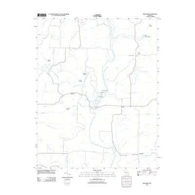
2012 Map of Billmore
USGS Topo · Published 2012About this map
The Eleven Point River flows through the center of this Ozark landscape, carving a winding path past the tight limestone formation known as The Narrows. This corridor supported a network of small, rural hubs such as Billmore and Calm, alongside several namesake features that speak to the area's agricultural and milling history. Notable among these is Thomasons Mill, situated near the confluence of Frederick Creek and the main river. To the north and south, the presence of the Water Post Office and Griswold Post Office indicates the enduring importance of these community centers for the dispersed residents of Oregon County.
Find a feature on this map
56 named features on this map. Tap any name to fly to it.
Don’t see what you’re looking for? This feature index may not catch every label — zoom into the map to look around manually.
Map Details
Editions of this 2012 Billmore Map
This is the sole edition of this map. No revisions or reprints were ever made.
Other maps of this area

1941 · Gatewood
USGS Topo · 1:62,500

1944 · Couch
USGS Topo · 1:62,500

1945 · Gatewood
USGS Topo · 1:62,500

1946 · Couch
USGS Topo · 1:62,500

1957 · Poplar Bluff
USGS Topo · 1:250,000

1959 · Poplar Bluff
USGS Topo · 1:250,000

1960 · Poplar Bluff
USGS Topo · 1:250,000
1965 · Riverton
USGS Topo · 1:24,000

1965 · Gatewood
USGS Topo · 1:24,000
1965 · Bardley
USGS Topo · 1:24,000