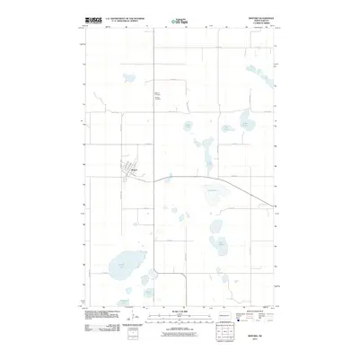
2011 Map of Binford
USGS Topo · Published 2011About this map
Binford serves as the central hub of this eastern North Dakota landscape, situated amidst a dense network of glacial prairie potholes and larger water bodies. The town's grid is clearly defined by streets such as Winery St and Harlan St, reflecting a settled agricultural community. To the north, the proximity of Bethany Cemetery and Binford Cemetery provides specific points of interest for genealogists tracing local family histories.
Find a feature on this map
33 named features on this map. Tap any name to fly to it.
Don’t see what you’re looking for? This feature index may not catch every label — zoom into the map to look around manually.
Map Details
Editions of this 2011 Binford Map
This is the sole edition of this map. No revisions or reprints were ever made.
Other maps of this area

1952 · New Rockford
USGS Topo · 1:250,000

1956 · New Rockford
USGS Topo · 1:250,000

1961 · Kloten NW
USGS Topo · 1:24,000

1961 · Binford
USGS Topo · 1:24,000

1961 · Jessie
USGS Topo · 1:24,000

1961 · Sutton
USGS Topo · 1:24,000

1961 · Binford NE
USGS Topo · 1:24,000

1961 · Cooperstown West
USGS Topo · 1:24,000
1961 · Binford NW
USGS Topo · 1:24,000

1961 · Sutton NE
USGS Topo · 1:24,000