
1961 Map of Sutton
USGS Topo · Published 1963About this map
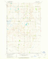
Sutton serves as the primary hub of activity in this 1961 survey of the North Dakota plains, situated at the junction of the Great Northern railroad and local transport routes. The landscape is defined by the winding course of Baldhill Creek, which meanders through the townships of Kingsley and Mabel. This document was prepared by the Geological Survey as part of the Department of the Interior's Missouri River Basin development program, illustrating the organized grid of section lines and field boundaries common to the region. A small Gravel Pit north of the main settlement suggests localized resource extraction supporting the area's infrastructure. The detailed plotting of individual structures in Sutton and the surrounding townships provides a clear look at the rural density and land use patterns of the early 1960s.
Find a feature on this map
7 named features on this map. Tap any name to fly to it.
Don’t see what you’re looking for? This feature index may not catch every label — zoom into the map to look around manually.
Map Details
Editions of this 1961 Sutton Map
This is the sole edition of this map. No revisions or reprints were ever made.
Other maps of this area

1900 · Pingree
USGS Topo · 1:125,000

1951 · Kensal SE
USGS Topo · 1:24,000

1951 · Glenfield
USGS Topo · 1:24,000

1952 · New Rockford
USGS Topo · 1:250,000

1956 · New Rockford
USGS Topo · 1:250,000

1961 · McHenry
USGS Topo · 1:24,000

1961 · Binford
USGS Topo · 1:24,000

1961 · Revere
USGS Topo · 1:24,000

1961 · Sutton NE
USGS Topo · 1:24,000
1961 · Mose
USGS Topo · 1:24,000