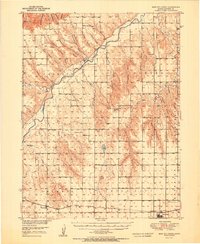
1951 Map of Bird City North
USGS Topo · Published 1951About this map
The South Fork Republican River cuts a deep, winding course through the western plains of Cheyenne County, defining the agricultural landscape of this high prairie region. In the early 1950s, the rural character of the area is underscored by a dense network of one-room schoolhouses serving isolated farmsteads, including White Lily Sch, South Fork Sch, and Riverside Sch. The southern portion of the map centers on the town of Bird City, a vital hub for the grain economy, supported by the tracks of the Chicago Burlington and Quincy railroad. Numerous canyons, such as Dave Harvey Canyon and Hells Canyon, break the tableland, while smaller landmarks like Horsethief Cave and several family-named ponds like Leach Pond provide unique reference points for local history and genealogy research.
Find a feature on this map
40 named features on this map. Tap any name to fly to it.
Don’t see what you’re looking for? This feature index may not catch every label — zoom into the map to look around manually.
Map Details
Editions of this 1951 Bird City North Map
2 editions found
Other maps of this area

1942 · St. Francis
USGS Topo · 1:62,500

1943 · St. Francis
USGS Topo · 1:62,500

1950 · Mc Donald
USGS Topo · 1:62,500

1951 · St Francis
USGS Topo · 1:62,500

1951 · Bird City North
USGS Topo · 1:62,500

1951 · Mc Donald
USGS Topo · 1:62,500

1951 · Bird City South
USGS Topo · 1:62,500

1951 · Dewey Ranch
USGS Topo · 1:62,500

1952 · St Francis 3
USGS Topo · 1:62,500

1954 · McCook
USGS Topo · 1:250,000