
1951 Map of Bird City South
USGS Topo · Published 1951About this map
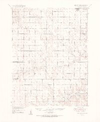
Bird City sits at the northern edge of this High Plains landscape, serving as a primary hub for a vast agricultural region at the start of the 1950s. The survey reveals a classic section-line road network that dictates the placement of essential community structures, particularly one-room schoolhouses like Cheyenne Valley Sch and South Star Sch that dot the townships of Alexander and Lawnridge.
Find a feature on this map
23 named features on this map. Tap any name to fly to it.
Don’t see what you’re looking for? This feature index may not catch every label — zoom into the map to look around manually.
Map Details
Editions of this 1951 Bird City South Map
2 editions found
Other maps of this area

1942 · St. Francis
USGS Topo · 1:62,500

1943 · St. Francis
USGS Topo · 1:62,500

1950 · Mc Donald
USGS Topo · 1:62,500

1951 · St Francis
USGS Topo · 1:62,500

1951 · Bird City North
USGS Topo · 1:62,500

1951 · Mc Donald
USGS Topo · 1:62,500

1951 · Dewey Ranch
USGS Topo · 1:62,500

1952 · St Francis 3
USGS Topo · 1:62,500

1954 · Goodland
USGS Topo · 1:250,000

1956 · Goodland
USGS Topo · 1:250,000