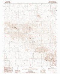
1988 Map of Bird Spring
USGS Topo · Published 1988About this map
The Gravel Hills dominate this arid landscape in San Bernardino County, where the terrain is marked by intricate drainage patterns and sparse water sources like Bird Spring. Surveyed in the 1980s, the map reveals a remote environment where human presence is primarily indicated by a network of 4wd tracks and occasional resource exploration sites. Several Mine and Prospect labels are located in the northern elevations, suggesting small-scale mineral activity typical of the Mojave desert region. In the southeastern corner, Black Mountain Canyon cuts through the high ground, while a Guzzler indicates artificial water management for local wildlife. The abundance of control points, labeled as VFGC and VFCC, underscores the high-precision topographical work conducted during this era to document this complex geomorphology.
Find a feature on this map
27 named features on this map. Tap any name to fly to it.
Don’t see what you’re looking for? This feature index may not catch every label — zoom into the map to look around manually.
Map Details
Editions of this 1988 Bird Spring Map
This is the sole edition of this map. No revisions or reprints were ever made.
Other maps of this area

1915 · Searles Lake
USGS Topo · 1:250,000

1947 · Trona
USGS Topo · 1:250,000

1948 · Trona
USGS Topo · 1:250,000

1953 · Trona
USGS Topo · 1:250,000

1954 · Pilot Knob
USGS Topo · 1:62,500

1954 · Cuddeback Lake
USGS Topo · 1:62,500

1955 · Opal Mountain
USGS Topo · 1:62,500

1956 · Fremont Peak
USGS Topo · 1:62,500

1957 · Trona
USGS Topo · 1:250,000

1960 · Trona
USGS Topo · 1:250,000