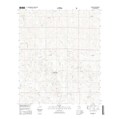
2015 Map of Birds Creek
USGS Topo · Published 2015About this map
Kisatchie National Forest defines the landscape of this Vernon Parish interior, where a network of forest roads and creeks crisscrosses a region defined by its timber and military utility. For genealogists, the map identifies small, isolated burial sites including Watson Cem in the north and Holly Springs Cem further south. The drainage patterns are intricate, with Birds Creek and Whisky Chitto Cr carving through the terrain alongside numerous branches like Calhoun Br and Coupen Br. The road system reflects the dual use of the land, featuring named routes like Artillery Rd and Bivouac Rd that suggest proximity to military training grounds, while Gravel Hill Church Rd points toward local community landmarks. The topography reveals the subtle shifts in elevation that separate the basins of W Fork Sixmile Cr and Little Sixmile Cr.
Find a feature on this map
33 named features on this map. Tap any name to fly to it.
Don’t see what you’re looking for? This feature index may not catch every label — zoom into the map to look around manually.
Map Details
Editions of this 2015 Birds Creek Map
This is the sole edition of this map. No revisions or reprints were ever made.
Other maps of this area
1941 · Slagle
USGS Topo · 1:62,500
1943 · Leander
USGS Topo · 1:62,500
1944 · Slagle
USGS Topo · 1:62,500
1947 · Chasmore
USGS Topo · 1:31,680
1947 · Sugrue
USGS Topo · 1:31,680
1947 · Pitkin
USGS Topo · 1:31,680
1951 · Pitkin
USGS Topo · 1:24,000
1952 · Lake Charles
USGS Topo · 1:250,000
1953 · Alexandria
USGS Topo · 1:250,000
1954 · Chasmore
USGS Topo · 1:31,680