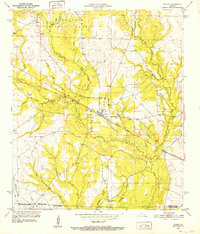
1951 Map of Pitkin
USGS Topo · Published 1952About this map
The settlement of Pitkin serves as a central hub in this mid-century survey, situated at a junction where the Atchison Topeka and Santa Fe railroad bisects the landscape. The map reveals a transition from the structured boundaries of the Kisatchie National Forest in the north to the more scattered homesteads and community landmarks further south. Rural life is anchored by family and faith sites like Mathis Cem and Mt Olive Ch, while the presence of an Old Railroad Grade near Little Brushy Creek points to the area's evolving transportation and logging history. Numerous watercourses, including Sixmile Creek and its many branches like Turkey Creek and Gum Branch, define the local drainage patterns. In the southern reaches, the Simmons Mill Ch and the small locality of Dido sit near the parish lines of Vernon, Allen, and Beauregard.
Find a feature on this map
28 named features on this map. Tap any name to fly to it.
Don’t see what you’re looking for? This feature index may not catch every label — zoom into the map to look around manually.
Map Details
Editions of this 1951 Pitkin Map
This is the sole edition of this map. No revisions or reprints were ever made.
Other maps of this area

1941 · Slagle
USGS Topo · 1:62,500

1943 · Leander
USGS Topo · 1:62,500

1944 · Slagle
USGS Topo · 1:62,500

1947 · Steep Gully
USGS Topo · 1:31,680

1947 · Elizabeth
USGS Topo · 1:31,680

1947 · Grant
USGS Topo · 1:31,680

1947 · Sugartown
USGS Topo · 1:31,680

1947 · Sugrue
USGS Topo · 1:31,680

1947 · Pitkin
USGS Topo · 1:31,680

1948 · Grant
USGS Topo · 1:24,000