
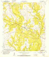
1947 Map of Steep Gully
USGS Topo · Published 1947About this map
Tenmile Creek and Steep Gully snake through this landscape where the boundaries of Vernon, Rapides, and Allen parishes meet. The area’s development in the mid-1930s was defined by timber and transit, evidenced by the numerous old logging railroad grades that crisscross the terrain, predating the more permanent State Highway No. 113. Near the southern edge, the Gulf Colorado and Santa Fe Railroad runs through Herberts Switch, marking a critical shipping point for the local economy.
Find a feature on this map
21 named features on this map. Tap any name to fly to it.
Don’t see what you’re looking for? This feature index may not catch every label — zoom into the map to look around manually.
Map Details
Editions of this 1947 Steep Gully Map
This is the sole edition of this map. No revisions or reprints were ever made.
Other maps of this area

1935 · Pawnee
USGS Topo · 1:31,680

1935 · Oakdale
USGS Topo · 1:31,680

1942 · Oakdale
USGS Topo · 1:62,500

1943 · Leander
USGS Topo · 1:62,500

1947 · Elizabeth
USGS Topo · 1:31,680

1947 · Grant
USGS Topo · 1:31,680

1947 · Pitkin
USGS Topo · 1:31,680

1948 · Grant
USGS Topo · 1:24,000

1948 · Elizabeth
USGS Topo · 1:24,000
1951 · Pitkin
USGS Topo · 1:24,000