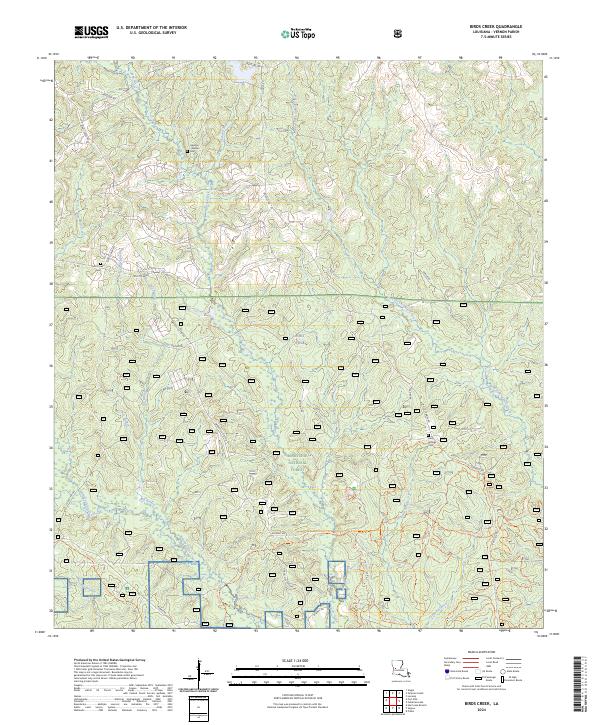
2024 Map of Birds Creek
USGS Topo · Published 2024About this map
Kisatchie National Forest dominates this landscape in Vernon Parish, where dense woodland is intersected by a complex network of waterways and tactical military infrastructure. The map reveals the southern reaches of Fort Polk, showing how the installation integrates with the surrounding natural terrain. A series of forest roads, including Whisky Chitto Rd and Lookout Rd, provide access to remote areas defined by landforms like Hog Ridge. Genealogists will find significant local value in the preservation of small, family-linked burial grounds such as the Haymon - Watson Cem, Mill Creek Cem, and Holly Springs Cem. The drainage patterns are clearly defined by the winding paths of Whisky Chitto Creek and Birds Creek, alongside numerous branches and forks that feed the region's river systems.
Find a feature on this map
36 named features on this map. Tap any name to fly to it.
Don’t see what you’re looking for? This feature index may not catch every label — zoom into the map to look around manually.
Map Details
Editions of this 2024 Birds Creek Map
This is the sole edition of this map. No revisions or reprints were ever made.
Other maps of this area

1941 · Slagle
USGS Topo · 1:62,500

1943 · Leander
USGS Topo · 1:62,500

1944 · Slagle
USGS Topo · 1:62,500

1947 · Chasmore
USGS Topo · 1:31,680

1947 · Sugrue
USGS Topo · 1:31,680

1947 · Pitkin
USGS Topo · 1:31,680
1951 · Pitkin
USGS Topo · 1:24,000

1952 · Lake Charles
USGS Topo · 1:250,000

1953 · Alexandria
USGS Topo · 1:250,000
1954 · Chasmore
USGS Topo · 1:31,680