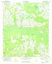
1974 Map of Birdsville
USGS Topo · Published 1976About this map
The Ogeechee River carves a broad, swampy path through this 1970s landscape, serving as a focal point for the landings and riverfront commerce that define the region. Access points like Bennetts Landing, Kents Landing, and Lane Landing dot the riverbanks, illustrating the enduring importance of the waterway even as the Central of Georgia railroad runs parallel to the north. The settlement of Birdsville sits at the northern edge, supported by the small Birdsville Airport and anchored by its proximity to the vast wetlands of Big Dukes Pond.
Find a feature on this map
39 named features on this map. Tap any name to fly to it.
Don’t see what you’re looking for? This feature index may not catch every label — zoom into the map to look around manually.
Map Details
Editions of this 1974 Birdsville Map
This is the sole edition of this map. No revisions or reprints were ever made.
Other maps of this area

1920 · Millen
USGS Topo · 1:62,500

1921 · Rocky Ford
USGS Topo · 1:62,500

1943 · Rocky Ford
USGS Topo · 1:62,500

1943 · Millen
USGS Topo · 1:62,500

1943 · Millen
USGS Topo · 1:125,000

1947 · Savannah
USGS Topo · 1:250,000

1948 · Savannah
USGS Topo · 1:250,000

1957 · Macon
USGS Topo · 1:250,000

1957 · Savannah
USGS Topo · 1:250,000

1958 · Macon
USGS Topo · 1:250,000