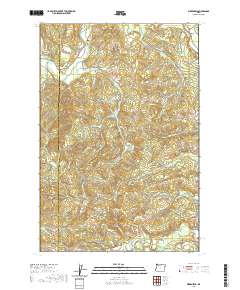
2020 Map of Birkenfeld
USGS Topo · Published 2020About this map
Birkenfeld and Mist sit within the timber-heavy landscape of the northern Oregon Coast Range, where the winding Nehalem River meets a network of logging infrastructure. This modern survey illustrates how historically significant forestry routes have evolved into modern access ways, such as the Kauppi Mainline and the Columbia River Main Line. These paths follow the natural drainages of Rock Creek and Deep Creek, highlighting a landscape defined by its watersheds. The Birkenfeld Bridge remains a key crossing point near the junction of Neverstill Rd, serving as a central landmark for this rural community. The map also records numerous family-named roads and remote water bodies like Kauppi Lake, which point to the generational land use and settlement patterns within the borderlands of Clatsop and Columbia counties.
Find a feature on this map
47 named features on this map. Tap any name to fly to it.
Don’t see what you’re looking for? This feature index may not catch every label — zoom into the map to look around manually.
Map Details
Editions of this 2020 Birkenfeld Map
This is the sole edition of this map. No revisions or reprints were ever made.
Other maps of this area

1919 · Mayger
USGS Topo · 1:62,500

1940 · Vernonia
USGS Topo · 1:62,500

1941 · Keasey
USGS Topo · 1:62,500

1941 · Clatskanie
USGS Topo · 1:62,500

1941 · Cathlamet
USGS Topo · 1:62,500

1943 · Vernonia
USGS Topo · 1:62,500

1943 · Keasey
USGS Topo · 1:62,500

1948 · Vancouver
USGS Topo · 1:250,000

1950 · Vancouver
USGS Topo · 1:250,000

1950 · Vancouver
USGS Topo · 1:250,000