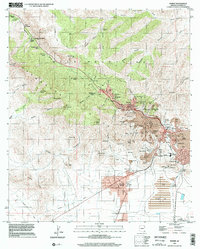
1996 Map of Bisbee
USGS Topo · Published 2002About this map
The Mule Mountains dominate this 1996 survey, which documents the profound intersection of geology and industry in the Bisbee district. The landscape is defined by massive extraction efforts, most notably the Lavender Pit and numerous tailings facilities including Tailings Dump No 7 and a large Tailings Pond to the south. The dense urban layout of Bisbee is intricately mapped, showing civic landmarks like City Hall, the hospital, and St Patrick Sch, alongside the residential neighborhoods of Lowell, Warren, and Bakerville. Historic transportation and infrastructure are clearly visible, from the Old Railroad Grade and Mule Pass to the Banning Toll Station (Site). Further south, the transition to flatter terrain near the Naco Hills includes Huachuca Terrace and the Bisbee Municipal Airport, reflecting the continued modern footprint of this copper-rich region.
Find a feature on this map
135 named features on this map. Tap any name to fly to it.
Don’t see what you’re looking for? This feature index may not catch every label — zoom into the map to look around manually.
Map Details
Editions of this 1996 Bisbee Map
This is the sole edition of this map. No revisions or reprints were ever made.
Other maps of this area

1902 · Bisbee
USGS Topo · 1:62,500

1910 · Bisbee
USGS Topo · 1:62,500

1914 · Hereford
USGS Topo · 1:125,000

1915 · Benson
USGS Topo · 1:125,000

1916 · Pearce
USGS Topo · 1:125,000

1916 · Douglas
USGS Topo · 1:125,000

1919 · Douglas
USGS Topo · 1:125,000

1925 · Gleeson
USGS Topo · 1:62,500

1927 · Bisbee
USGS Topo · 1:62,500

1932 · Stark
USGS Topo · 1:62,500