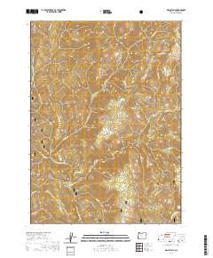
2020 Map of Biscuit Hill
USGS Topo · Published 2020About this map
Siskiyou National Forest dominates this mountainous landscape in Curry County, where the North Fork Smith Wild and Scenic River carves a path through the western terrain. The hydrology of the area is exceptionally dense, defined by the N Fork Smith River and its many tributaries, including Baldface Cr, Hardtack Cr, and Chrome Cr. The topography is marked by significant elevations like Red Mountain in the northwest and Biscuit Hill in the east, which rises above the waters of Biscuit Cr. A single corridor labeled Sourdough provides the primary passage through the southern portion of the quadrangle, crossing Pack Saddle Gulch. This map illustrates a region managed for conservation, where the network of named creeks such as Spokane Cr and Fall Cr highlights the complex drainage system of the Klamath Mountains.
Find a feature on this map
23 named features on this map. Tap any name to fly to it.
Don’t see what you’re looking for? This feature index may not catch every label — zoom into the map to look around manually.
Map Details
Editions of this 2020 Biscuit Hill Map
This is the sole edition of this map. No revisions or reprints were ever made.
Other maps of this area
1917 · Kerby
USGS Topo · 1:125,000
1918 · Kerby
USGS Topo · 1:125,000
1922 · Preston Peak
USGS Topo · 1:125,000
1929 · Crescent City
USGS Topo · 1:125,000
1945 · Kerby
USGS Topo · 1:125,000
1945 · Gasquet
USGS Topo · 1:62,500
1945 · Point St. George
USGS Topo · 1:62,500

1948 · Weed
USGS Topo · 1:250,000
1949 · Eureka
USGS Topo · 1:250,000

1950 · Weed
USGS Topo · 1:250,000