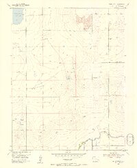
1955 Map of Bishop Ranch
USGS Topo · Published 1956About this map
The high plains of Bent County are defined by a sophisticated system of water management and livestock ranching in this mid-century topography. The northern portion of the landscape is dominated by the Adobe Creek Reservoir, while the southern reaches are structured by the Fort Lyon Canal and its associated Levee. This irrigation infrastructure allowed for the development of rural homesteads and named properties such as Bishop Ranch and the Cordes-Oberlander Ranch.
Find a feature on this map
19 named features on this map. Tap any name to fly to it.
Don’t see what you’re looking for? This feature index may not catch every label — zoom into the map to look around manually.
Map Details
Editions of this 1955 Bishop Ranch Map
3 editions found
Other maps of this area

1891 · Las Animas
USGS Topo · 1:125,000

1893 · Las Animas
USGS Topo · 1:125,000

1953 · Las Animas
USGS Topo · 1:24,000

1953 · Cornelia
USGS Topo · 1:24,000

1953 · Kreybill
USGS Topo · 1:24,000

1954 · Lamar
USGS Topo · 1:250,000

1955 · Tree Top Ranch
USGS Topo · 1:24,000

1955 · Mc Intosh Ranch
USGS Topo · 1:24,000

1955 · Bishop Ranch
USGS Topo · 1:24,000

1958 · Lamar
USGS Topo · 1:250,000